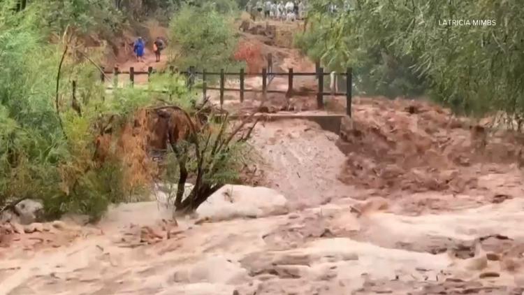
Flash Floods in the American Southwest
Flash floods can strike even when it’s sunny outside, especially in the canyon-covered American Southwest.
SUPAI, Ariz. — When a group of hikers were caught in a flash flood that left one woman dead and triggered the evacuation of over 100 people, they were barely getting rained on.
On Thursday, Aug. 22, Havasu Creek near Supai village was struck by a devastating flash flood. But that event didn’t start in the immediate area. Radar images from that day showed that the storms responsible formed up to 10 miles away.
RELATED: An Arizona woman went missing after a flash flood in Havasu Canyon. Her body was found about 20 miles down stream 3 days later.
That day, Chenoa Nickerson was hiking in the creek with her husband when a flash flood struck and swept them away. Although her husband was rescued by a group of rafters, Nickerson went missing. She would be found dead three days later and 20 miles away.
In 2008, a severe flood in the area permanently changed the flow of the creek and left more than 450 hikers stranded. Last year, dozens of people were stranded in Havasupai Village by similar flooding.
Stories like these are common to the American Southwest, where the canyon-covered landscape is primed to channel water into intense, fast-moving floods.
“This is canyon country,” explained NWS Flagstaff Meteorologist-in-Charge Dr. Brian Klimowski. “Water isn’t absorbed very well at all when it falls, and when you get torrential rainfall, like in this event, it runs off very quickly and accumulates in these narrow canyons.”
Many of these canyons are connected to a large drainage basin via miles of rivers and creeks. During monsoon storms, a massive amount of water is forced into smaller areas, rapidly increasing its depth and force.
Most of the water that caused last week’s flooding fell not on the Supai area, but within 5 to 10 miles of it, Klimowski explained. Even if it started miles away, it didn’t take long for the flood to hit.
Below: A map of the Havasu Canyon Watershed provided by the Grand Canyon National Park shows how steep many of the surrounding canyons and formations are.
“Within 30 minutes to an hour-and-a-half [it] was causing the destructive flooding that we saw,” he said. The storms that caused the 2008 flood were 20 to 50 miles upstream and only took a few hours to hit the populated area.
Klimowski explained that flash floods move at roughly 6 to 8 mph. Although that doesn’t seem like a lot on paper, water moving at that speed carries a lot of force. A person can be swept away by as few as 18 inches. A car will float away in just 20 inches.
For those looking to hike safely in flood-prone areas, Klimowski recommended prevention, preparation and knowing when it’s time to leave.
“If you’re in a narrow canyon and you hear thunder, you might not see where it is, but you know there are thunderstorms near,” he said. “It’s time to get out. Use your ears. Use your eyes. If you see the signs of storms building in the area, it’s time to get out.”
The National Weather Service maintains forecasts and early warnings for areas like the Grand Canyon National Park. They’ll issue an alert when flooding is imminent or underway and often have warnings as early as the day before.
But if you are caught in a dangerous situation, Klimowski says it’s important to know how to find safe locations. Look for wide, open areas that are well above the water level and avoid camping in dry streambeds.
More than 100 people had to be airlifted out of Havasu Canyon by the Arizona National Guard after the flooding. The trail to Havasu Canyon, the Havasupai Campground and the Havasu Falls areas are closed indefinitely, according to the Havasupai Tribal Council.
>> Download the 12News app for the latest local breaking news straight to your phone.
12News on YouTube
Catch up on the latest news and stories on our 12News YouTube playlist here.


